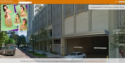
The Beat Shows Geotagged Instragram Pictures w/ Google Street View
have you heard about The Beat by Rutgers’ Social Media Information Lab? The site uses Instagram’s API to tie geotagged photos to their physical location captured in Google’s Street View. The site lets you filter images by hashtag, so you can search for pretty much anything you want and the site will return a constant stream of Instagramed pics, as well as the Street View location at which they were taken. So, that is what $1.5 million in federal grants can do when it comes to new computing applications. Stalkers around the world are rejoicing!

We use Instagram pictures users added to their map, and combine them with the corresponding Google StreetView location to help explore topics in a new way. Try it! This is a project of the Social Media Information Lab, at the School of Communications and Information at Rutgers University.

Comments are closed.